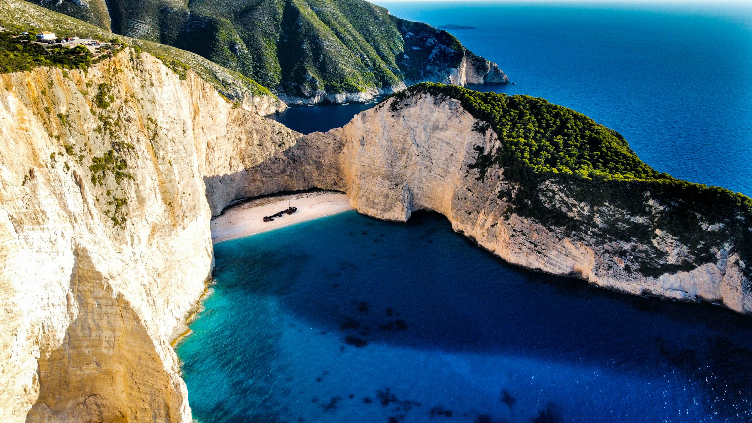
For a beach that virtually nobody is allowed to actually stand on anymore, Navagio has an unusual talent for showing up in everyone’s camera roll.
Tucked into a narrow cove on the northwest coast of the Greek island of Zakynthos, its white sand, 200-meter limestone cliffs, and the rusting hull of a decades-old shipwreck have made it arguably the single most photographed stretch of coastline in Europe – and, for four consecutive tourist seasons now, one of the very few you can look at but never touch.
The Shipwreck That Turned a Hidden Cove Into a Global Icon
Before it became one of the most photographed beaches in Greece, Navagio was simply a remote cove on the northwestern coast of Zakynthos.
Known as Agios Georgios, the beach was difficult to reach and largely cut off from the rest of the island. Then, in October 1980, a freighter built in 1937 called the MV Panagiotis came ashore on its sand. The ship never left.
What happened that night has become one of the most enduring mysteries surrounding Greece’s most famous beach. The basic facts are relatively straightforward. The Panagiotis ended up stranded in the cove during a period of bad weather, and the crew abandoned the vessel.
But the circumstances behind the wreck have been debated for decades. One version says the Panagiotis was carrying a large cargo of contraband cigarettes, while another says the ship had been on a legitimate voyage between Kefalonia and Albania and that bad weather and mechanical failure forced it toward the beach.
Whatever the circumstances, the outcome was extraordinary. The isolated cove proved almost impossible to access by land, and the abandoned vessel was left where the sea had put it.
Its steel hull gradually rusted against the brilliant white limestone and gravel, creating a scene that looked almost too perfectly arranged to be real. The transformation was eventually reflected in the name itself. Navagio means “shipwreck” in Greek.
For years, the beach remained a spectacular but relatively obscure corner of Zakynthos. Then photography changed its fate.
The contrast was irresistible: a rusting freighter surrounded by white cliffs, turquoise Ionian water and a narrow strip of pale sand. Images of the cove began appearing in travel magazines, guidebooks and promotional material, turning an obscure maritime accident into a visual symbol of the Greek islands.
By the age of social media, the transformation was complete. Navagio became one of the images most closely associated with Greece, attracting travelers who wanted to see in person the scene they had already encountered countless times on postcards, websites and Instagram feeds.
And that may be the strangest chapter in the Panagiotis story. A ship whose final voyage remains wrapped in conflicting accounts ended up creating something nobody on board could possibly have anticipated: one of Europe’s most recognizable beaches.
A Season That Runs on Ferries and Sunlight
Navagio’s tourist calendar follows the rhythm of the wider Greek islands: the season typically opens in earnest around late April or May, builds toward a peak in July and August when Mediterranean heat and school holidays align, and tapers off through September and October before most boat tours and ferry connections wind down for winter.
Because the cove has never had road access (it sits at the base of sheer cliffs with no path down from the clifftop) every visitor for decades has arrived the same way tourists do today: by boat, launched from Porto Vromi, Agios Nikolaos, or Cape Skinari on the other side of the island, weather permitting. That seasonal boat traffic became, in its own way, part of the problem.
Why the Beach Actually Closed
Navagio’s cliffs have never been especially stable, and the geology behind that instability is straightforward: rainwater and groundwater work their way into cracks at the top of the limestone face for years without visibly changing anything at the surface, until gravity finally wins and a section gives way with essentially no warning.
The bay’s tight, amphitheater-like shape makes that danger worse rather than better – there’s nowhere for a falling rock mass to go except straight down onto the sand below.
The first major warning came in 2018, when part of the cliff face broke away and crashed onto the beach, injuring seven people and generating a localized wave inside the enclosed bay violent enough to make international headlines.
The beach reopened afterward, but the reprieve didn’t last. In September 2022, a magnitude 5.4 earthquake struck the waters between Zakynthos and neighboring Kefalonia, triggering a fresh, larger rockfall along the cove’s cliffs.
Greece’s Earthquake Planning and Protection Organization, known by its Greek acronym OASP, inspected the site afterward and classified the entire bay as unsafe for landings – a designation that has effectively held ever since.
What started as a seasonal precaution has hardened into a standing rule. The closure has now been extended for four consecutive tourist seasons, covering 2023, 2024, 2025, and 2026, with the current order – formalized through a Joint Ministerial Decision published in Greece’s Government Gazette – keeping both a “Prohibited Zone” and a wider “Controlled Access Zone” off-limits through October 31, 2026.
Under the current rules, setting foot on the sand, swimming in the bay, and touching the wreck are all banned outright, and boats are required to hold a minimum distance of roughly 50 meters from shore. Violators face fines enforced jointly by the Municipality of Zakynthos and the Hellenic Police.
There’s a second motive behind the restrictions beyond visitor safety: protecting what’s left of the Panagiotis itself.
Decades of storms have battered the wreck badly, and Greek authorities have since unveiled plans to extend the beach roughly 30 meters seaward using imported gravel, specifically to push the shoreline – and the waterline – further from the ship’s remains and slow the corrosion and structural damage the sea has been inflicting on it for over 40 years.
How People Are Still Seeing It Legally
None of this has actually kept Navagio off anyone’s itinerary. Two legitimate ways to experience the cove remain fully open, and together they still draw enormous numbers of visitors every season.
The first is by sea. Licensed tour boats and private charters can still enter the bay itself, holding position at the permitted distance from shore, which is more than close enough to photograph the wreck, the cliffs, and the water that made the beach famous in the first place.
The second is from above: a clifftop viewing platform near the village of Anafonitria, reachable by road, offers the sweeping aerial angle that produced most of the beach’s iconic photography to begin with – the same vantage point, more or less, that made Navagio an Instagram fixture years before most visitors ever considered the view might someday be the only version available.
That’s very different from illegal access, which remains a real and persistent problem. Reports of tourists and some tour operators quietly ignoring the boundary – anchoring closer than permitted, or in isolated cases attempting to land – continue to surface each season, prompting periodic enforcement crackdowns and fines.
Authorities have been explicit that the restrictions apply to the entire bay, not just the strip of sand directly beneath the wreck, and that penalties apply regardless of how briefly someone steps ashore.
Navagio Isn’t a One-Off
As dramatic as Navagio’s closure sounds, it fits a pattern that keeps repeating across Europe’s most scenic coastlines, where towering cliffs and packed summer beaches turn out to be a dangerous combination almost everywhere they occur together.
Research on coastal rockfalls has found that fatal collapses cluster heavily around the summer months – not because the rock becomes more unstable in warm weather, but because that’s precisely when most people are gathered directly beneath it.
Portugal’s Algarve coast delivered the starkest example. On August 21, 2009, a section of cliff roughly ten meters high sheared away from Maria Luísa beach near Albufeira without warning, killing five people – four women and a 60-year-old man – despite warning signage already posted at the site.
A court later found the Portuguese state liable for inadequate risk monitoring and ordered over €1 million in compensation to the victims’ families.
In England, the crumbling cliffs of Dorset’s Jurassic Coast have claimed lives too; a 2012 rockfall at Burton Bradstock killed a 22-year-old woman walking beneath the cliffs with no warning at all.
Greece has its own precedent beyond Zakynthos: Porto Katsiki, another cliff-backed beach on the neighboring island of Lefkada, has seen fatal rockfalls of its own tied to both earthquake activity and gradual natural erosion.
And as recently as 2026, a rockslide covering more than 2,000 square meters collapsed near a lighthouse in Biarritz, France, killing a woman on the shore below and leaving a diver missing.
The pattern connecting all of these sites is the same one Greek geologists cited when they closed Navagio: what scientists sometimes describe as a hollow-dome effect, in which a cliff face can look entirely solid from below while water has already fractured it from within, with nothing visible to warn beachgoers before it fails.
Combine that invisible instability with a very human habit – beachgoers gravitating toward the shade directly beneath the cliffs on the hottest days of the year – and the risk compounds in exactly the spot where people are most likely to be standing.
The Bottom Line
Navagio isn’t going anywhere, and neither is its fame. What’s changed is the terms of the encounter. For now, and very possibly for the foreseeable future, one of Europe’s most photographed beaches is a look-but-don’t-touch destination – best experienced from the deck of a boat holding its distance, or from a clifftop platform hundreds of feet above the sand nobody’s allowed to walk on anymore.
Sources and Further Reading:
- Government Gazette of Greece – Joint Ministerial Decision on access restrictions at Navagio Bay, Zakynthos (2026)
- The Culture Trip, “How Did The World’s Most Famous Shipwreck Come To Be?” — for the competing accounts of the wreck and the captain’s version of events.
- Proto Thema, “Ναυάγιο Ζακύνθου: Η ιστορία του πλοίου «Παναγιώτης»” – reporting based on historical testimony and documents concerning the alleged cigarette-smuggling operation.
- ERT News, “Οκτώβριος 1980 – Όταν το Motorship ‘Παναγιώτης’ προσάραξε στην Ζάκυνθο” – historical reconstruction of the events surrounding the wreck.
- Discover Greece, “A boat trip to Shipwreck beach in Zante” – background on the wreck and its transformation into an iconic Zakynthos attraction.
- Euronews Travel – Greece’s famous ‘Shipwreck Beach’ to be extended to save its iconic wreck
- ToVima – Zakynthos: Navagio Beach Access Curbs Extended Through 2026
- Pappas Post – Zakynthos Shipwreck Beach Remains Shut for the Duration of Summer 2026
- France 24 / NBC News – coverage of the 2009 Maria Luísa beach cliff collapse, Albufeira, Portugal
- Portugal Resident – State sentenced to pay €1 million to families of Maria Luísa rock fall victims
- Organization for Anti-Seismic Planning and Protection (OASP), Greece – official risk assessments for Navagio Bay
/This article is intended for general educational and travel-interest purposes. Access rules and closure dates for Navagio Beach are subject to change; readers planning a visit should confirm current restrictions with local authorities or licensed tour operators before travel./


