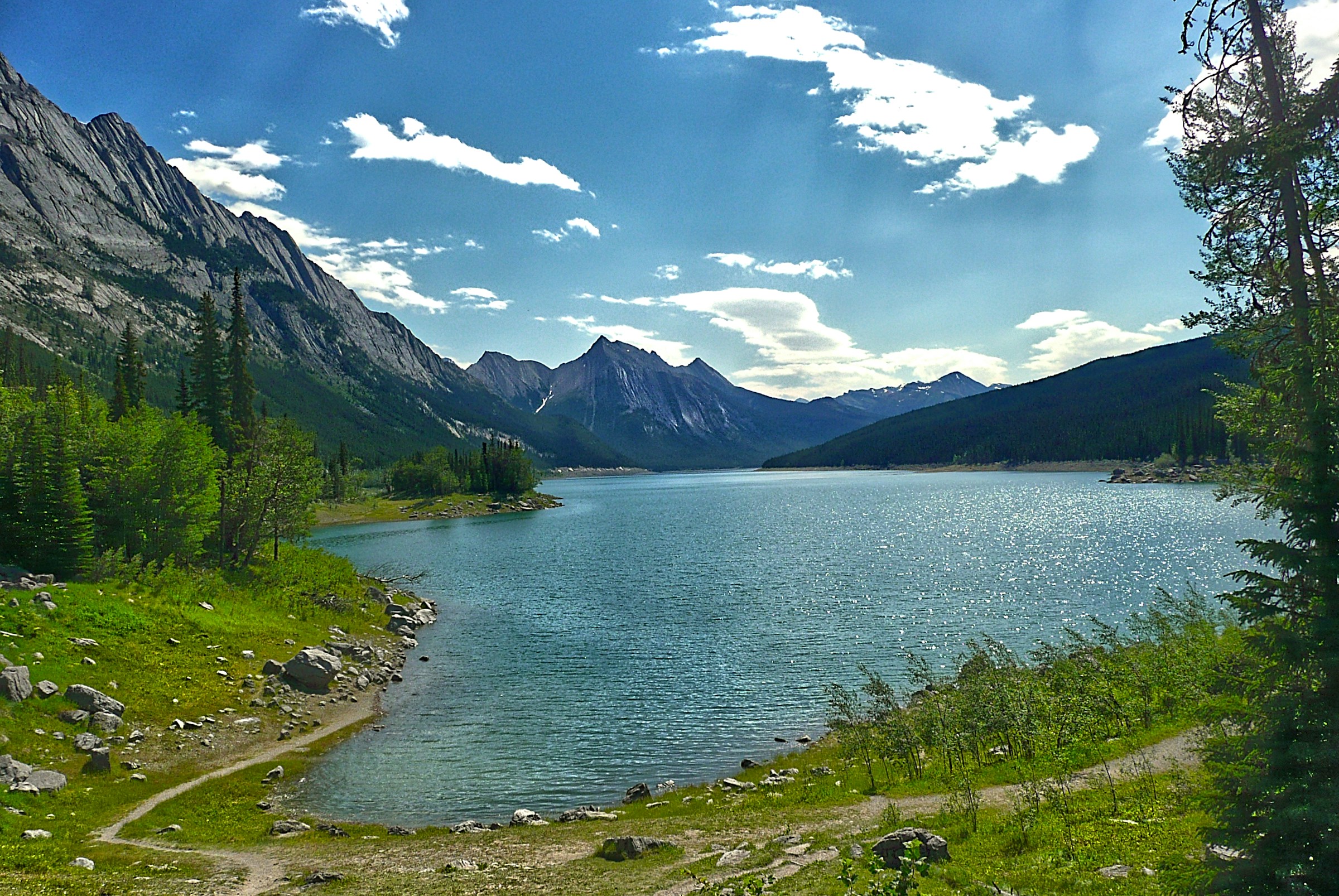
Visit Medicine Lake in Jasper National Park in July and you’ll find a long, shimmering stretch of glacier-fed water framed by Rocky Mountain peaks, with a road tracing its shoreline and brook trout rising in the shallows.
Come back in November and the water is gone. In its place lies a broad expanse of gray mud, a thin stream meandering through the middle, and animal tracks crisscrossing ground that was a lakebed a few weeks earlier.
Nothing was drained by people, and nothing was dammed or diverted. The lake simply leaves, every year, and returns the next spring. It’s one of the most unusual landscapes in the Canadian Rockies, and for generations, nobody could say where the water went.
A River With a Drain in the Floor
Medicine Lake sits about 20 kilometers (12 miles) southeast of the town of Jasper, in Alberta, along the road to the better-known Maligne Lake.
It stretches roughly 7 kilometers (4.3 miles) end to end and is relatively shallow. In summer, the lake reaches its maximum depth of around 20 meters.
This is when glacial melt is at its most intense, and the enormous inflow of water fills the lakebed to the brim. By autumn and winter, however, the story is entirely different: the depth drops to nearly zero.
Once underground caves drain the water away, the lake all but disappears, leaving behind only a shallow, meandering river and a few small muddy pools.
Geologists describe it as a geological anomaly because it functions less like a standing body of water than like a wide spot in a river.
The Maligne River, flowing north out of Maligne Lake toward the Athabasca River, pools here and then, for most of the year, vanishes into the ground. Hydrologists call this kind of waterway a “losing stream.”
The easiest way to picture it is a bathtub with the tap running and the drain open. In late spring and summer, meltwater from the surrounding glaciers and snowfields pours into the basin faster than the underground system can swallow it, so water backs up and the lake fills.
As autumn arrives and the melt slows to a trickle, the drains keep working at roughly the same pace. The basin empties, and the lake becomes a mudflat with a small river running through it until the next season’s melt begins.
“Big Medicine”
The Indigenous peoples whose traditional territory includes the Maligne Valley, among them Nakoda, Cree, and Dane-zaa nations, watched this cycle for generations.
A lake that filled and emptied with no visible outlet looked like the work of powerful forces, and the place came to be known as Medicine Lake, a name that reflects spiritual power rather than anything related to healing. Early European travelers adopted it, and it has stuck ever since.
The mystery lingered into the age of tourism, and so did the frustration. The unpredictable water levels complicated the effort to bring visitors up the valley to Maligne Lake, and over the years, park managers tried some decidedly low-tech fixes.
Accounts differ on the exact timing, with both the 1930s and the 1950s cited, but several describe attempts to plug the sinkholes with old mattresses and bundles of magazines, and at one point, a dam was floated as an idea. None of it worked. The holes were far larger than anyone had assumed.
Following the Water With Red Dye
The real answer came from science. In the 1960s and 1970s, researchers poured nontoxic fluorescent dye into the lake’s sinkholes and then waited to see where it would surface. The results surprised them.
Red rhodamine dye turned up roughly 14 kilometers away as the raven flies, in a cluster of springs along the walls of Maligne Canyon.
The actual underground path is longer, usually put at around 16 kilometers (10 miles). The dye was also detected at Lac Beauvert, the lake beside Jasper Park Lodge, which showed that the plumbing extends well beyond the canyon itself.
Even the speed of the journey told its own story. According to a geological guide published by the Canadian Federation of Earth Sciences, dye-laced water completes the trip in as little as 12 to 24 hours in summer, then slows to between 5 and 9 days in winter, when flow is much lower.
A hydrogeological study of the system by C. C. Smart, published in the Journal of Hydrology in 1988, helped quantify how the network behaves.
The system is widely described as the longest known underground drainage network in Canada and one of the largest in North America.
A Cave Nobody Has Fully Seen
The scale of the flow points to something remarkable underground. Based on the volume of water and the pace it travels, cave scientists believe the Maligne karst, the term for terrain shaped by water dissolving limestone, must contain at least one major cave.
Reaching it has proved impossible. Several entrances to the system are known, but in each case the passage is blocked, and the largest stretches of this underground river have never been seen by human eyes.
What comes out of the other end is easier to see. Maligne Canyon is a slot canyon up to about 55 meters (180 feet) deep and 1.2 kilometers long, carved into the Palliser Formation, a thick layer of limestone laid down in a shallow tropical sea hundreds of millions of years ago.
Underground streams join the river at the canyon’s springs, which is why the river is fuller there than the dry riverbed upstream would suggest.
Geologists have noted that the canyon is oddly narrower at the top than partway down, a clue that it may have started life as a cave whose roof was later stripped away by glaciers.
Life on the Lakebed
The disappearing water hasn’t made the lake lifeless. Eastern brook trout, reportedly stocked here in 1927, have managed to survive the annual drawdown, apparently by sheltering in pools and the remaining stream.
When the lake is gone, wildlife moves in to explore, and the mudflats become a record of who passed through. In one widely shared image, a black bear sleeps in front of a den it dug in the dry lakebed.
Seeing It Yourself
Timing matters. The lake is typically at its fullest from about June to mid-September, depending on the year’s snowpack and rainfall.
By late fall and winter, it’s a mudflat, which is its own kind of spectacle. Both versions are worth a look.
Medicine Lake sits inside Jasper National Park, which is part of the Canadian Rocky Mountain Parks UNESCO World Heritage Site, and a Parks Canada pass is required for entry.
For all the dye and data, the lake still holds something back. Scientists can tell you where the water goes.
They have never fully seen how it gets there, which makes Medicine Lake a good reminder that even in one of the most visited parks in North America, a large piece of the landscape runs through the dark.
Sources: C. C. Smart, “Quantitative tracing of the Maligne karst system, Alberta, Canada,” Journal of Hydrology (1988); Canadian Federation of Earth Sciences, Maligne Canyon GeoVistas brochure (Ben Gadd, 2011); Parks Canada and Jasper Tourism materials on Medicine Lake and Maligne Canyon; Wikipedia entries on Medicine Lake (Alberta), the Maligne River, Maligne Canyon, and Jasper National Park; National Parks Traveler; SunDog Tours.


