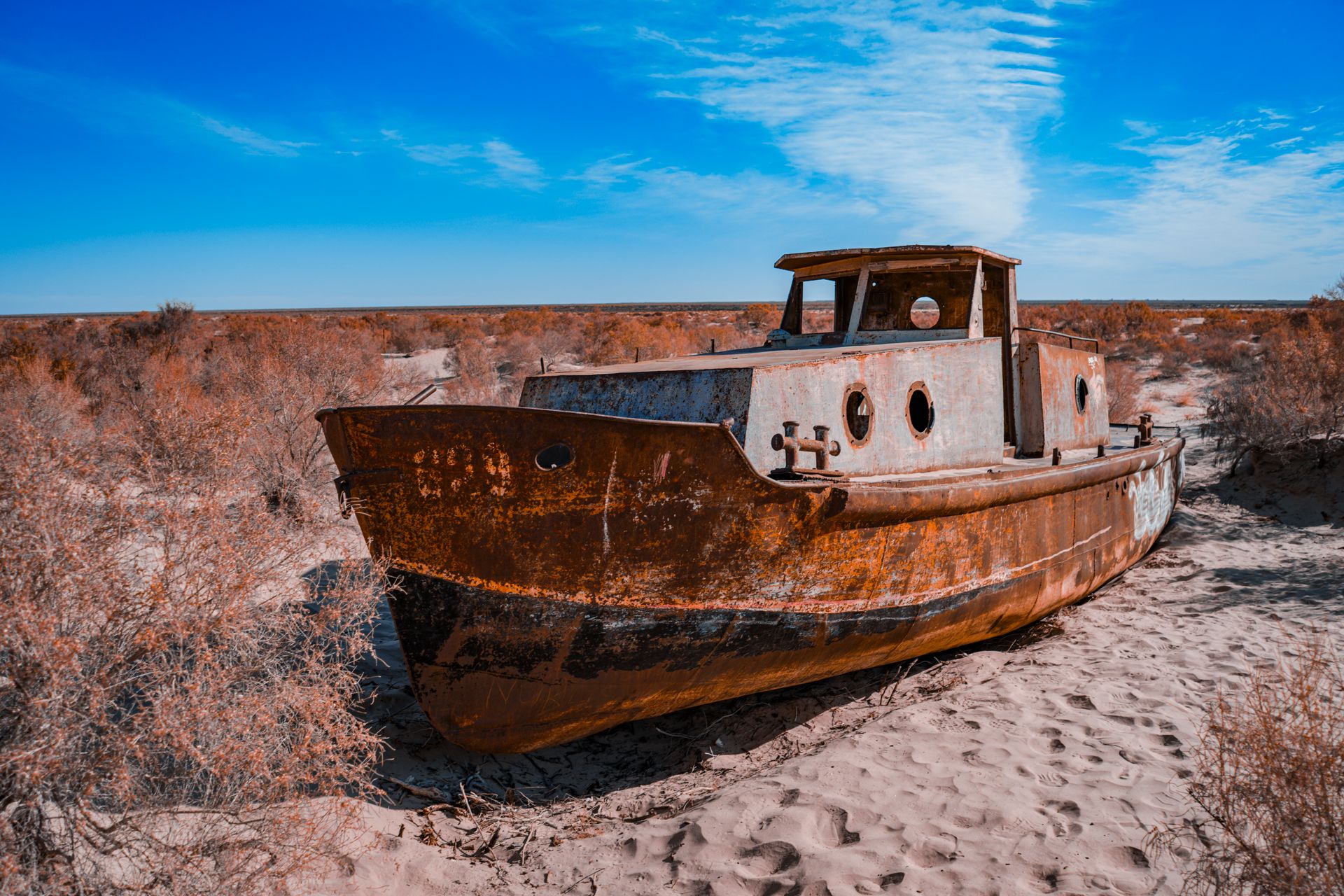
It was once the world’s fourth-largest lake. Within fifty years, it became a desert — and a graveyard of rusting ships sitting on dry, cracked seabed hundreds of kilometers from the nearest water.
68,000 km²: original surface area – once the world’s 4th-largest lake
~90% of total volume lost since 1960
68 m: original maximum depth
2005: the Kokaral Dam – the one place the sea is coming back
There is a particular kind of silence that settles over a dead sea. Not the silence of an empty wilderness, which at least has wind and birds, but the silence of a place that used to be something else entirely – fishing boats, harbor cranes, the smell of salt water – and now is just sand, stretching to a horizon where water should be.
That silence is what greets visitors today at Moynaq, a town in Uzbekistan that was, within living memory, a thriving port. The nearest shoreline now sits more than 150 kilometers away.
This is the Aral Sea – or what’s left of it. Straddling the border of Kazakhstan and Uzbekistan in the heart of Central Asia, it was once one of the great inland bodies of water on Earth.
Today, large portions of it are simply gone, and the story of how that happened is one of the starkest examples in modern history of how quickly human decisions can erase something nature spent millennia building.
Not a Sea but the Fourth-Largest Lake in the World
Before its collapse, the Aral Sea spanned roughly 68,000 square kilometers – an area nearly the size of Georgia, Ireland, Sri Lanka, or the U.S. state of West Virginia.
It was the fourth-largest lake on the planet, a brackish, slightly saline body of water reaching depths of up to 68 meters.
Despite the name “sea,” it was technically an endorheic lake, meaning it had no outlet to any ocean – its water balance depended entirely on what flowed in from its two feeding rivers, the Amu Darya and the Syr Darya, against what evaporated under the harsh Central Asian sun.
That balance, for thousands of years, held. The Aral supported a substantial fishing industry – Aral sturgeon, carp, and other freshwater species sustained entire port towns along its shores.
Its river deltas were green, biodiverse corridors in an otherwise arid region, and the sea itself moderated the local climate, softening the brutal extremes of the surrounding desert.
The Illusion of the 1960s: Cotton Over Water
The Aral’s decline traces back to a single Soviet-era decision. In the 1960s, central planners in Moscow set out to transform the arid plains of Uzbekistan and Turkmenistan into vast cotton plantations – chasing what was internally referred to as “white gold.”
The plan required enormous quantities of irrigation water, and the only source large enough was the Amu Darya and Syr Darya – the same two rivers that had sustained the Aral Sea for millennia.
Soviet engineers diverted both rivers into an extensive network of irrigation canals. Many of those canals were poorly built and unlined, leaking and wasting much of the water they carried before it ever reached a cotton field.
The consequence for the Aral was immediate, if initially invisible to most people: the sea’s main water sources were being siphoned away, faster than rainfall and minor tributaries could replace them.
At first, almost no one noticed. Through the 1960s, the water level dropped by only a few centimeters a year – slow enough to be dismissed, ignored, or rationalized.
Soviet planning documents from the era reportedly treated the sea’s eventual disappearance as an acceptable cost, with some officials describing the Aral Sea itself as one of nature’s mistakes – water in the wrong place, doing too little for the regional economy compared to cotton.
The Point of No Return
By the 1970s and 1980s, the slow decline became a collapse. Annual water-level drops accelerated to as much as a meter per year.
The sea, which had been a single connected body of water, began splitting into separate basins as its shrinking shoreline retreated from itself – eventually forming a distinct North Aral Sea in Kazakhstan and a South Aral Sea in Uzbekistan, with the South later splitting further into eastern and western lobes.
As the volume of water collapsed, salinity rose dramatically – eventually exceeding the salt concentration of the open ocean in parts of the shrinking South Aral. Few fish species could tolerate it.
The Aral’s once-thriving fishing industry, which had employed tens of thousands of people and supplied a significant share of the Soviet Union’s fish catch, collapsed entirely within a generation.
Port towns like Moynaq found themselves stranded, sometimes by tens of kilometers, as the water that had defined their economy and identity simply receded out of reach.
1960: Soviet irrigation diversion begins; the Aral Sea sits at its full historical extent of roughly 68,000 km².
1960s-70s: Gradual decline of a few centimeters per year, largely ignored by planners and the public.
1980s: Decline accelerates to roughly 1 meter per year; the fishing industry begins to collapse as salinity rises.
1987: The sea splits into a separate North Aral Sea and South Aral Sea as the shrinking shoreline divides.
2005: Kazakhstan completes the Kokaral Dam, sealing off the North Aral and beginning its recovery.
2014: The eastern lobe of the South Aral Sea dries up completely for the first time in modern history.
What’s Left: The Aralkum, and the Ships of Moynaq
Where the southern Aral Sea once stood, a new desert has emerged – the Aralkum, now considered one of the youngest deserts on Earth, born directly on the exposed, salt-encrusted seabed of a lake that took thousands of years to fill and less than fifty to empty.
The most visited, and most photographed, symbol of that collapse sits at Moynaq, once a prosperous Uzbek fishing port on the Aral’s southern shore.
Today, a cluster of rusted fishing vessels sits stranded in the sand, hulls tilted at odd angles, paint long since stripped by decades of sun and salt wind.
It has become one of Central Asia’s most striking dark-tourism destinations: a literal ship graveyard, kilometers from the nearest drop of water, where tourists now walk on what used to be a seabed and climb into boats that once sailed there.
“One of the planet’s worst environmental disasters.”
– UN Secretary-General Ban Ki-moon, after visiting Moynaq in 2011
The damage extends well beyond the dried lakebed itself. Decades of intensive cotton farming left the former seabed saturated with residual pesticides, fertilizer salts, and agricultural chemicals.
As wind sweeps across the exposed Aralkum, it lifts tons of this toxic dust and salt into the air, carrying it – by some estimates – thousands of kilometers across Central Asia.
Public health researchers have linked the resulting air pollution to elevated rates of respiratory illness, anemia, and other health problems among communities living near the former shoreline, who now breathe in a slow-motion legacy of the sea’s disappearance long after the water itself is gone.
Two Seas, Two Futures
What makes the Aral’s story more than a simple tragedy is that its two halves are no longer following the same trajectory – and the difference between them says a great deal about political will, geography, and economic incentive.
NORTH ARAL – KAZAKHSTAN
In 2005, Kazakhstan completed the 13-kilometer Kokaral Dam, sealing the North Aral off from the rapidly evaporating South and trapping inflow from the Syr Darya river.
The results outpaced expectations: water levels rose roughly 12 meters within years, salinity dropped from around 30 grams per liter to roughly 8, and more than twenty freshwater fish species returned.
By 2025, the total water volume in the North Aral had grown to 27 billion cubic meters, with annual fish catches reaching around 8,000 tons – a fishing industry genuinely reviving after near-total collapse.
A second phase of dam expansion, planned for 2026 to 2029, aims to raise water levels further still.
SOUTH ARAL – UZBEKISTAN
No equivalent project exists for the South Aral, and its outlook remains bleak. The eastern lobe dried up completely in 2014.
What little remains is hypersaline and largely lifeless. Rather than pursuing restoration, Uzbekistan has instead begun extracting natural gas and oil from the exposed seabed of the former South Aral – a development that gives the country a direct economic incentive in the desert remaining a desert, rather than becoming a sea again.
THE NORTH ARAL, BY THE NUMBERS
Fish catch: 695 metric tons in 2005 → roughly 8,000 tons by 2025, a more than tenfold increase. Ten fish-processing plants now operate in the Aral region, four holding EU export certification, sending thousands of tons of fish to over a dozen countries each year.
The Lesson of a Sea That Disappeared
The Aral Sea’s collapse remains one of the clearest illustrations on record of how an ecosystem assumed to be permanent – a body of water spanning tens of thousands of square kilometers, supporting fishing fleets and entire towns – can be unmade within a single human lifetime, not by some unforeseeable natural catastrophe, but by a sustained policy choice that treated the sea as expendable.
The North Aral’s partial recovery proves the damage wasn’t entirely irreversible – given enough water, enough engineering, and enough political commitment, even a “dead” sea can show real signs of life again.
But the South Aral’s continued disappearance, and the gas wells now operating on its dry former floor, are an equally important part of the lesson: recovery requires not just the will to act, but the absence of a competing reason not to. Where that incentive existed, the sea came back. Where it didn’t, it’s still vanishing.
References:
- Wikipedia – “Aral Sea” (original surface area, depth, historical extent). en.wikipedia.org
- NASA Earth Observatory – “World of Change: Shrinking Aral Sea.” earthobservatory.nasa.gov
- Eurasianet – “Kazakhstan: Measuring the Northern Aral’s Comeback” (Soviet irrigation history, fishing industry collapse). eurasianet.org
- Euronews – “North Aral Sea regains a third of its water thanks to restoration efforts” (2026) – South Aral status, Aralkum desert, gas extraction. euronews.com
- World Bank – “Saving a Corner of the Aral Sea” (Kokaral Dam project details, financing). worldbank.org
- National Geographic – “The North Aral Sea Teems With Fish Thanks to Restoration Projects.” nationalgeographic.com
- Global Voices – “How Kazakhstan resurrected the North Aral Sea” (2026) – 2025 water volume, fish catch, 2026–2029 dam expansion. globalvoices.org
- Euronews – North Aral Sea restoration update (fish processing plants, export figures). euronews.com


